
28 June 2019

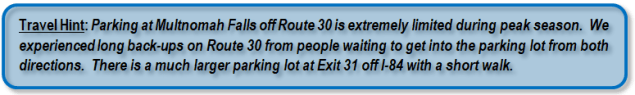
The Columbia River Gorge is an area I have been anxious to visit for a long time. It did not disappoint. The Columbia River serves as the border between Oregon and Washington. On the Oregon side, Interstate 84 travels along the river and rivals the I-70 corridor through Colorado as my favorite interstate drive. But we didn’t come all this way to drive past quickly so we took Historic Route 30. The western end of Route 30 starts in Troutdale, Oregon and goes eastward parallel to the Columbia River and I-84. Along the route there are several lookouts, waterfalls, and hiking trails. At Dodson we jumped onto I-84 to ride along the river.

Latourell Falls

Bridalveil Falls

Multnomah Falls
 edit2")
 edit2")
 edit2")
Horsetail Falls, Upper (top right and bottom) and Lower (top left)

Wow, your photos look absolutely amazing and so does Columbia River Gorge, would love to visit one day, thanks for sharing 😀
LikeLiked by 1 person