Fjordland National Park – Part 2

22 – 23 February 2018

Pic 2018-0222 01 Milford Sound Foreshore (36) Edit

Milford Sound is the end of the Te Anau-Milford Highway. If you want to go any further, you’ll need to take any number of trails, boats, airplanes, or helicopters that are available. We had hoped to take a boat tour of the Sound but lost a day to rain. Instead we limited ourselves to two short walks. The Milford Sound Foreshore Track is a park highlight. The Milford Sound Lookout Track is a short walk to a lookout tht gives you the same view as the previous walk but further away. It wasn’t worth our time. The reason we took it was my fault.

When I was researching and planning our trip, I read that Donald Sutherland’s grave site was on the trail, which it is. The problem with my half-baked research was Donald Sutherland, the actor, is not dead. Donald Sutherland, the area’s founding father and longtime resident, is. I thought it would be intersting to see the grave of a Hollywood legend. We were less interested in the other.

Pic 2018-0222 02 Milford Lookout (2) Edit

Milford Sound Lookout Track

Pic 2018-0223 07 Marian Falls (3) Edit

Pic 2018-0223 08 River at Marian Falls (20) Edit

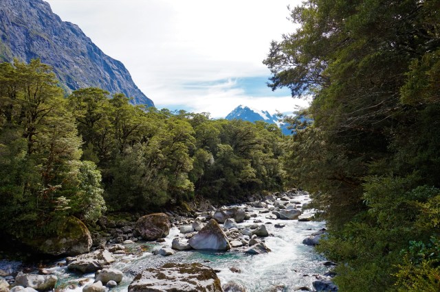
Marian Falls and River


Posted in New Zealand, South Island | Tagged , , , , , , | Leave a comment

Fjordland National Park – Part 1

20 – 23 February 2018

Pic 2018-0222 11 Fjordland NP (63) Edit

Our travel from Fox Glacier to Te Anau felt more like an evacuation than a road trip. We had been nervously watching the track of Cyclone Gita. Our campsite in Fox Glacier could be hit hard so we got up before the sun and drove hard to get as far south as we could before landfall. We made a few stops along the way but mostly kept pushing south. Between narrow roads, rain, road construction, and campers, the drive took all day. In the end, we arrived at our cabin in Te Anau while Gita hit the West Coast causing most of its damage along the path we took from Picton to Greymouth just a few days ago. Over night the storm produced snow in the mountains we passed through the day before.

The first full day in Te Anau was a wash out. We used the day to relax and get ready for the next two days. No complaints though, TV news reported storm damage throughout the middle of the country including the areas we just spent the past few days. The next morning dark skies broke and the sun came out. We took advantage of good weather and explored Fjordland National Park.

Fjordland National Park is an amazing place. When we thought of New Zealand, this is what we imagined. A truely beautiful place, the park has plenty for any nature lover. It has several multi-day trails however we are not equipped to do them. We, like the majority of visitors, stuck to the park’s readibly accessible highlights. The Te Anau-Milford Highway is the main spine of the park with the most popular sights located along it.

Here are a few places we visited, with more to follow.

Pic 2018-0222 19 Te Anau (29) Edit

Lake Te Anau

Pic 2018-0222 10 Homer Tunnel (21) Edit

Homer Tunnel Lookout

Pic 2018-0223 10 Lake Gunn (1) Edit

Pic 2018-0222 12 Lake Gunn (9) Edit

Lake Gunn

Pic 2018-0223 09 Lake Fergus (1) Edit

Lake Fergus

Pic 2018-0222 04 Tutoko River Bridge (10) Edit

Tutoko River Bridge

Posted in New Zealand, South Island | Tagged , , , , , , , , | Leave a comment

Franz Josef Glacier and Fox Glacier

19 February 2018

Pic 2018-0219 04 Franz Josef Glacier (82) Edit

Another 100 miles down Route 6 from Hokitika Gorge we arrived at Franz Josef Glacier (above). Originally we intended to take a short walk to the lookout but once we were there we could not help but walk to the end of the trail. It didn’t hurt that once again we got lucky and the rain broke to allow us to enjoy stretching our legs for awhile. The glacier is an extremely popular sight. We were surprised at the number of visitors. It reminded me of Bear Glacier outside Stewart in British Columbia, Canada with one exception, at Bear Glacier I was the only person in sight.

Waterfalls on the trail to Franz Josef Glacier

Fox Glacier is a short drive south of Franz Josef. We were excited to see another however Fox experience was less exciting. The drive up to the car park is passable for most cars and trucks but not appropriate for buses and campervans. The River Walk Trail was closed due to weather so with a short stroll we only got a distant view.

Pic 2018-0219 05 Fox Galcier (6) Edit

Fox Glacier below the mist

Another popular stop in the Town of Fox Glacier is Lake Matheson. The walking trails include a circuit around the entire lake. If you are lucky it provides a view of Mount Cook and Mount Tasman reflecting in the placid lake surface. We weren’t that lucky. The weather was cloudy and rainy with impending landfall of Cyclone Gita. We stayed the night in a cabin near the lake.

Lake Matheson with Mount Cook and Mount Tasman as we hoped to see it (left) and how we saw it (right)

Posted in New Zealand, South Island | Tagged , , , , , , | Leave a comment

Hokitika Gorge

19 February 2018

Pic 2018-0219 02 Hokitika Gorge (19) Edit

On our drive down the West Coast from Greymouth to Fox Glacier, we reached inland about 20 miles west of Hokitika. Hokitika Gorge is a short walk from the car park. The water in the gorge is an amazing shade of milky blue-gray. We got lucky and had a small window between rain clouds to see the gorge. It and the area’s rivers reminded me of rivers I saw in the Yukon Territory of Northwestern Canada

Posted in New Zealand, South Island | Tagged , , , , | Leave a comment

Pancake Rocks and Blowholes

18 February 2018

Pic 2018-0218 07 Pancake Rocks (55) Edit

About 30 miles north of Greymouth near the town of Punakaiki are the Pancake Rocks and Blowholes. We all really enjoyed this stop. The viewing platforms are along a short walk along the shoreline. As you can see, the Pancake Rocks are uniquely sculpted by nature to loolike, well, pancake stacks. The surf roared in and the blowholes were quite active. Overall a fantastic place to spend an hour.

Posted in New Zealand, South Island | Tagged , , , | Leave a comment

Picton to Greymouth

17 – 18 February 2018

Pic 2018-0217 02 Picton (18) Edit

After 16 days on North Island, we were excited to explore New Zealand’s South Island. The North Island is where the majority of New Zealander’s live. The South Island is supposed to be the more scenic. From our first few days here, we are excited to see more.

Instead of flying we took the Interislander Ferry from Wellington to Picton. The ship crosses Cook Strait and takes 3-1/2 hours from dock to dock. The seas were a bit rough in the middle and smooth on both ends.

The first afternoon we drove from Picton to Nelson taking the scenic route along the coastline from Picton to Cullen Point. Nelson was a nice small town with everything we needed to stock up for the trek down the West Coast.

The next day we continued down Route 6 to Greymouth. The first half of the drive was through a countryside with more cows than people. The second half snaked along the shore and edge of Paparoa National Park. Greymouth was another nice-sized town to spend the night and get a good meal. Before arriving in Greymouth we stopped at the Pancake Rocks and Blowholes, more about that next post.

Pic 2018-0217 02 Picton (6) Edit

Town of Picton, Gateway to the South

Pic 2018-0217 04 Cullen Point (5) Edit

View from Cullen Point

Route 6 – Picton to Greymouth

Posted in New Zealand, South Island | Tagged , , , , , , , | Leave a comment

Wellington: Te Papa Tongarewa

16 February 2018

Pic 2018-0215 06 Mt Victoria (28) Edit

On our last full day in Wellington we were anticipating rain, which never came, so we planned to spend it inside the Museum of New Zealand or Te Papa Tongarewa. The museum is free, except special exhibitions. The exhibits include Maori culture, natural science and history, New Zealand Wars, and WWI’s Gallipoli campaign.

It’s hard to beat The Great War Exhibition to learn about New Zealand’s involvement in WWI but Te Papa has an impressive exhibit, ‘Gallipolo: The Scale of Our War’. The exhibition features several larger than life representations of soldiers and nurses who contiributed to the war effort. We had never seen anything like it before.

The exhibits of Maori culture, the New Zealand Wars, and the effects of volcanos and earthquakes on New Zealand were similar in quality to the War Memorial Museum we visited 2 weeks ago in Auckland.

We got lucky. They had a special exhibit of Legos which our kids loved. We spent plenty of time marvelling at the Lego reproductions of iconic world structures.

The museum is located on the waterfront in the heart of Wellington so there were plenty of options when we finally left to grab dinner.

Pic 2018-0216 02 Te Papa Museum (27) Edit

Gallipolo: The Scale of Our War


Posted in New Zealand, North Island | Tagged , , , , , , , , | Leave a comment

Wellington: The Great War Exhibition

15 February 2018

Pic 2018-0215 06 Mt Victoria (36) Edit

As part of our walk from the city center to Mount Victoria, started in Mount Cook at the Pukeahu National War Memorial Park and The Great War Exhibition. We have been fortunate enough to visit some fantastic museums in our lifes and The Great War Exhibition must go on our top-10 list. It is a must see for anyone intersted in World War history.

The museum stands out because it was designed and created in a unique way, through the guidance of film-maker Peter Jackson (Lord of the Rings, Hobbit, King Kong). The scenes are movie quality, the pictures are bright and colorful, and the collection is a step above others we’ve seen. The museum tells a story as you walk through from start to end of World War I. Very well done.

Adjacent from the front entrance is the National War Memorial which stands out in the city skyline. The Hall of Memories is in the base of the tower.

The Great War Exhibition

National War Memorial

Posted in New Zealand, North Island | Tagged , , , , | Leave a comment

Wellington: Cable Cars

13 – 17 February 2018

Pic 2018-0214 09 Cable Car Museum (16) Edit

The Wellington Cable Car was high on my to do list when I started to research the city. Growing up in Pittsburgh, the Duquesne Incline is iconic. Wellington’s cable cars looked quite familiar. They are a quick way to get up and down the terraces and worth a ride just for fun. They are your best option to visit the Botanical Gardens and Victoria University from the city center. The overlook at the top provides 180-degree views of the city and harbour and the Cable Car Museum is free.

At museum we learned about the long history of cable cars in New Zealand. Two items stuck out for me.

First, privately owned cable cars are used throughout Wellington for residential uses. Many of the houses peculiarly perched on the sides of the mountains use cable cars to scale the mountain side, connecting their garage or car park to their house. We saw them several times when we walked the Mount Victoria area. Great way to commute but I’m not sure how safe I’d feel.

Second, the first electric driven cable cars in New Zealand were built in Philadelphia. The city of Dunedin purchased them from J G Brill Company, the same manufacturer of Pittsburgh’s beloved Duquesne Incline cable cars. The Wellington cars were manufactured locally using what the engineer learned from Dunedin. It’s a small world.

Lookout from the Top

Pic 2018-0215 08 Mt Victoria (9) Edit

Residential Cable Car Tracks

Posted in New Zealand, North Island | Tagged , , , , | 1 Comment

Wellington: City Center

13 – 17 February 2018

Pic 2018-0215 06 Mt Victoria (30) Edit

To complete our tour of New Zealand’s North Island we spent several days in the country’s capital, Wellington. Wellington is the second largest city, however at about 417,000 residents it is much smaller than flagship Auckland.

Located on the southwestern tip of North Island, Wellington is a center of government, business, and shipping. And wiith the success of filmmaker Peter Jackson, his studios in the Miramar neighborhood have added the nickname ‘Wellywood’.

We know it better as ‘Windy Welly’. We heard it was windy but had no idea just how true that was. Wind whipped through the city all day and night with gusts that almost stopped me in my tracks. It is the windiest city in the world based on annual average wind speed.

We toured the city by foot. It is small enough but the changes in elevation make it tougher than it looks on a map. The city starts at the shoreline and expands up the mountains. Some of our favorite places to visit were the wharfs on Lambton Harbour, Parliament, Mount Victoria, The Great War Exhibition, Te Papa, and the Cable Cars.

City Center

Parliament Buildings

Old St. Pauls

Botanical Gardens

Pic 2018-0216 06 Cuba Street Mall (9) Edit

Chinese New Year on Cuba Street

Posted in New Zealand, North Island | Tagged , , , , , | Leave a comment